Magnetic Declination in Ireland
Understanding Magnetic Declination
You can get yourself bent out of shape trying to understand the concept on magnetic declination in Ireland. Lets deal with some of the issues we need to fully understand….there are Three Norths 🤷♂️….Really!! 😂
The Three Norths: True North
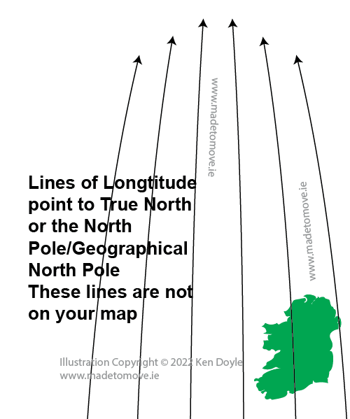
Fig 1: We need to understand a little about the ‘Three Norths’ before dealing with Magnetic Declination in Ireland. True North is where Santa lives, The North Pole or Geographic North. If we look at a globe there are lines that run ‘up and down’ the globe joining The South Pole to The North Pole. These lines are lines of Longitude. These lines converge on the North and South Poles. Our maps do give us some information about lines of longitude but the ‘grid’ we see printed on our maps are not showing lines of longitude. We don’t really need to worry about ‘True North’ when taking a bearing in Ireland. At times people may say it is the same as Grid North. It is sometimes in specific circumstances but generally we don’t need to worry about it. It is mentioned here so you are aware of it.
The Three Norths: Grid North
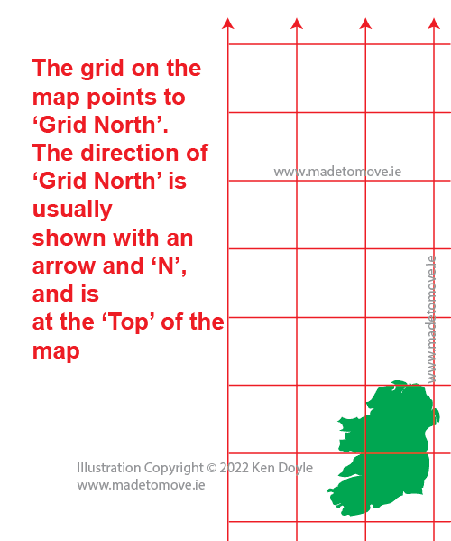
Fig 2: The grid we see printed on our Irish maps is the National Grid. It is unique to Ireland and covers only the Island of Ireland. When we speak about ‘Grid North’ we are speaking about that ‘Grid’. All the lines pointing ‘North’ are parallel to each other. The space between the lines printed on our maps is 1 kilometre. So we have a grid 1Km x 1Km. All the lines on our maps that are pointing to the ‘Top’ of our maps are said to point to Grid North.
The Three Norths: Magnetic North

Fig 3: Magnetic North is where the red magnetic needle on your compass points.
Magnetic North is not at the North Pole. The magnetic north drifts about over time according to magnetic changes in the Earth’s core. It used to move at a predictable rate so we could print that information on a map for future use. However it has become less predictable recently, speeding up and slowing down, so the information printed on our maps may not be accurate.
This is important because we depend on our red magnetic needle on our compass to point at Magnetic North so we can use our bearings accurately. I usually tell my clients that we were navigating accurately and not getting lost before we were aware of ‘Magnetic North’ as we rarely depend on just a bearing. However it is nice to be more accurate. If we know how much difference there is between Grid North and Magnetic North then we do some simple addition or subtraction to accommodate the difference.
The difference between Grid North and Magnetic North is called Magnetic Declination
What is Magnetic Declination?
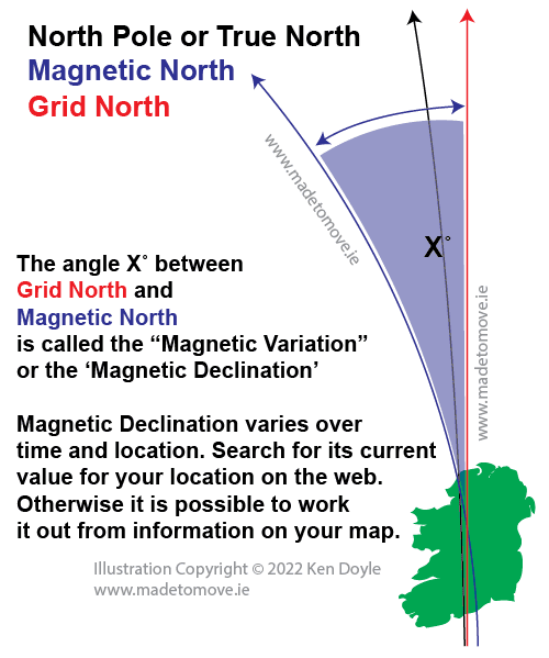
Fig 4: Shows the three norths together. This is not to scale and is not intended to show the exact position or difference between the three norths. The important part is the angle ‘X’. It is an approximation of Magnetic Declination. At any given time or place on the Island of Ireland the angle X will be different. The difference may be very small and something we may not need to worry about or it may differ up to a degree or more in different parts of the country.
We need to know what ‘X’ or magnetic declination is. Our printed maps can’t keep up with the changes unless they are printed every year with fresh accurate information.
We can find accurate information on the website Magnetic-declination.com
The website allows you to drop a pin anywhere and see what the magnetic declination is for that location. Have a play and see what the magnetic declination is for your location. Try a locations in different parts of the country and see the difference.
Adjusting for magnetic declination
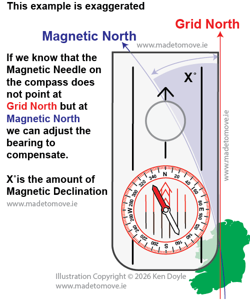
Fig 5: Shows how the difference between Magnetic North and Grid North may look. This is exaggerated of course. It is enough to know that if we don’t adjust or correct for the difference our bearing will not be accurate
Adjusting for magnetic declination
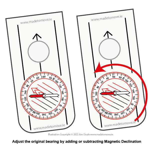
Fig 6: If you look at the page ‘How to take a bearing using a compass‘ you will see in the example that we took a bearing from our map of 52˚.
Lets say our Magnetic Declination at our location is 4˚.
If our bearing has been taken from the map and we are bringing it to the landscape to walk on a bearing we add the amount of Magnetic Declination to our original bearing.
From Map to Land: Map is small. Land is big: Add
We add 4˚to our bearing of 52˚ by rotating the compass bezel gently to 56˚. This is the bearing we now follow when walking on our bearing.
From Land to Map: Land is big. Map is small: Subtract
If we take a bearing from Land to Map we reverse the process: Subtract
Out bearing on land from ‘A’ to ‘B’ is 56˚. We take 4˚ from our bearing of 56˚ by rotating the compass bezel gently to 52˚. We can now place the compass on the map and locate point ‘B’.
Magnetic Declination will change depending on your location so look it up before you need it