How to Take a Grid Reference Using The Irish National Grid
There are lots of ways to explain the concept of The National Grid and how to take a grid reference. I like to start with a simple concept of columns and rows and then add more detail once we understand the fundamental principal.
This example will not deal with using a romer scale.
Learn about using a romer scale in Ireland here.
The Irish National Grid Has 25 100Km x100Km Boxes
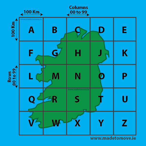
Fig 1: Shows an outline map of the Island of Ireland. The map is divided into 5 columns and 5 rows. That is a 5×5 grid with 25 individual boxes. Each column and row is 100Km wide. Each 100Km x100Km box is given an identifying letter, A to Z. The Letter ‘I’ is not used as we only need 25 letters and ‘I’ can be easily confused with ‘L’ or ‘1’.
The ‘National’ grid covers the entire Island of Ireland. It does not extend across the Irish Sea to Great Britain. There is a similar system used in Great Britain but the two systems do not align. The National Grid we use does not use lines of Longitude or Latitude.
Each 100Km x 100Km box is divided into 100 columns and 100 rows
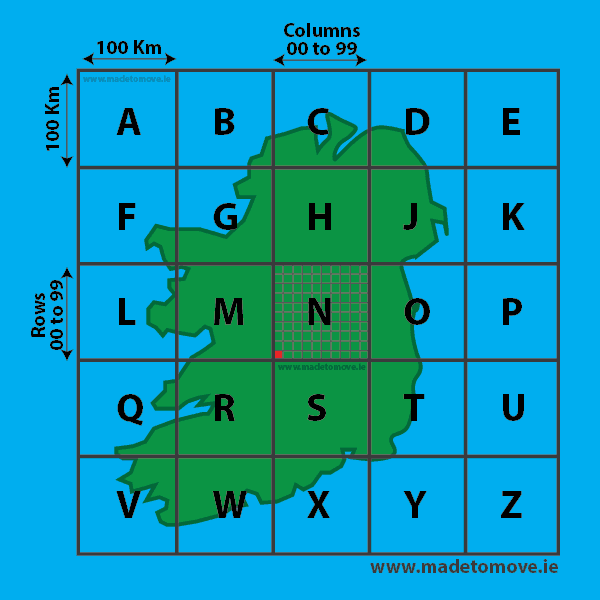
Fig 2: Shows the ‘Letter’ box ‘N’ which is 100Km x100Km divided into 100 columns and 100 rows. Not all columns and rows are shown for clarity. Each column and row is 1Km wide. Every column and row has it’s own number from 00 to 99.
Each letter box has the exact same grid numbers so each grid reference we give on the island of Ireland must start with a letter to Identify which ‘Letter’ box we are in.
Any Grid reference in ‘Letter’ box ‘N’ will start with ‘N’. Grid reference N 00 00 refers to the first column and the first row in the ‘Letter’ box N. Which is the bottom left hand corner of the ‘Letter’ box N. It’s the red box. In this example the columns and rows are not to scale for clarity!!
If you were in ‘Letter’ box S your grid reference would start with S.
Grid reference columns and rows
Up to now we have been dealing with the overall structure of the National Grid. Now we want to add more detail and see how our grid references fit into the overall system.
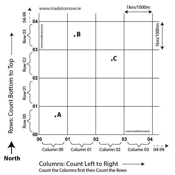
Fig 3: Let’s start with a simple concept. Columns and Rows. The ‘Letter’ box drawn on the map of the Island of Ireland is divided into a set of columns and rows. Each column and row drawn on the map is 1 kilometre or 1000 metres wide. (Regardless of the scale of the map.) It has nothing got to do with the National Electric Grid!!😁
We can find the grid reference for any location in Ireland by identifying the ‘Letter’ box we are in then what column and then what row the location is in. Each column and row has its own number from ’00’ to ’99’. We will add a little bit more detail to this concept later.
Count columns first then count rows second
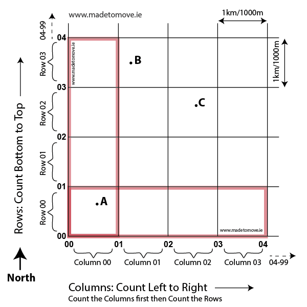
Fig 4: Imagine that we are looking at a map of ireland. North is at the top of the map so South is at the bottom. West is on the left and East is on the right. We count the numbers for the columns first. Count the columns from left to right as we look at the map. We count the rows second. Count the rows from bottom to top.
Count left to right then bottom to top
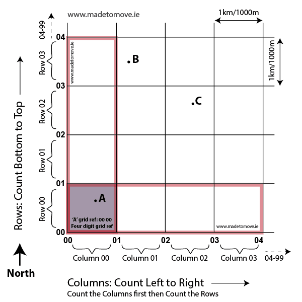
Fig 5: In this example the location ‘A’ is in column ’00’ (or ZERO ZERO). Location ‘A’ is in row ’00’ (or ZERO ZERO).
So the four digit grid reference for location ‘A’ is the intersection of the column and row which is: ’00 00′. The first ZERO ZERO refers to the column, the second ZERO ZERO refers to the row. This is a four digit grid reference. We give the column number first and the row number second. Count the columns from left to right and the rows from bottom to top.
Depending on what area of the country we are in we would identify what ‘Letter’ box we are in and add the letter to the beginning of the grid reference. So if Location ‘A’ was in ‘Letter’ box N the grid reference would be N 00 00.
A 4 digit grid reference is 1000 metres x 1000 metres
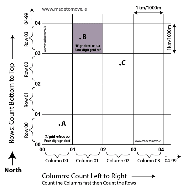
Fig 6: A grid reference does not give a reference to a point on a map it gives a reference to an area on the map. The more numbers we add to the grid reference the more detail we have and the smaller the area we refer to. Location ‘A’ with grid reference ’00 00′ is in a square, 1 kilometre x 1 kilometre.
The location ‘B’ is in column 01 and in row 03. Location ‘B’ has a grid reference of 01 03. That is a 4 digit grid reference which refers to an area 1000 metres x 1000 metres.
That’s a big area! What happens if we want to meet someone there for lunch? It’s a big area to search. So how can we add more detail?
A 6 digit grid reference is 100 metres x 100 metres

Grid Reference Adding The Additional Digit
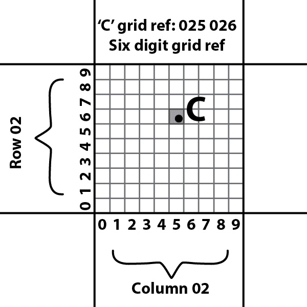
Fig 8: The imaginary grid that we divide the 1Km x 1Km square into has columns and rows that are 100 metres wide. There are 10 columns across and 10 rows up. The first column is counted as ZERO. The first row in the imaginary grid is counted as ZERO.
Our original 1KM x 1Km 4 digit grid reference for location C was 02 02. Location C is in imaginary column 5 and imaginary row 6. So we add those numbers to our original 4 digit grid reference to get a six digit grid reference.
We add ‘5’ to our column count to get 025 and we add ‘6’ to our row count to get 026. That is a six digit grid reference, 025 026. That is an area 100 metres x 100 metres.
If ‘Location’ C is in ‘Letter’ box N then the grid reference for ‘Location’ C is N025 026.
IMPORTANT: if we don’t give the ‘Letter’ for the grid reference then we could be referring to one of 25 grid references with the same numbers. Each ‘Letter’ box has the same grid. So start with the number first.
Grid Reference Eastings and Northings
Now for a technical term. When we count the columns first we count from left to right on the map, so we are counting from West to East on the map. Because we are counting toward the East the first set of numbers in a grid reference referring to the columns is called the ‘Easting’.
When we count the rows second we count from bottom to top on the map, so we are counting from South to North on the map. Because we are counting towards the North the second set of numbers in a grid reference referring to the rows is called the ‘Northing’. It’s important to give the column count or Easting first followed by the row count or Northing second.
Ordnance Survey Map of Ireland, Wicklow sheet 56
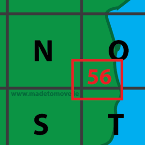
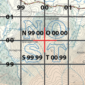
Fig 9: Shows the area of Ireland that the Irish Ordnance Survey map sheet ’56’ covers. Sheet ’56’ spans an area that covers parts of the grid covered by the 100km x100Km squares N,O,S and T.
Fig 10: Shows what sheet ’56’ looks like where the four ‘Letter’ boxes meet. The red cross hair shows the meeting point. The following grid references are shown:
Top right of ‘S’: S 99 99. Bottom right of N: N 99 00. Bottom left of O: O 00 00. Top left of T: T 00 99